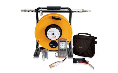
The Digital Uniaxial Bluetooth Horizontal Inclinometer system has been specially developed for high accuracy and resolution measurement and monitoring of settlement or heave under embankments, dams, landfill and storage tanks.
The Horizontal Digital Inclinometer System is used to manually measure settlement and/or heave within a horizontal borehole.
The system comprises a uniaxial probe, cable reel and a rugged Field PC supplied with ‘In-Port’ data logging software.
The probe, fitted with spring loaded guide wheels, is inserted into specially installed inclinometer casing which is either embedded in fill or secured to the structure to be monitored. A Kevlar reinforced graduated cable connects the probe to the cable reel and hub. Readings are then transmitted quickly and efficiently to a rugged Field PC via a Bluetooth link.
Product Features
- Wireless connectivity
- Field PC with enhanced custom software
- Metal marker/cable gate system
- Kevlar reinforced cable
- Bluetooth connection between cable reel and Field PC
- Accurate and precise readings using a MEMS sensor
- Supplied with ‘In-Port’ software to use with Field PC for easy data capture
Product Benefits
- Elimination of cable resistance and noise issues
- Repeatable depth control using metal markers and cable gate system
- Interfaces with most office systems and applications
- Easy data gathering
- Long, trouble-free use
- High degree of accuracy and repeatability
- No water ingress or connection failures
- Light and easily portable
- Able to take a day’s worth of readings on a single battery charge
Horizontal Inclinometer Operation
The inclinometer probe is inserted into horizontal inclinometer casing in 0.5metre increments; this is measured by metal markers crimped around the cable (also at 0.5m increments) and controlled by a notch in the cable gate. This ensures accurate and repeatable data when taking multiple readings.
Each increment of data is read by means of a key fob: the key fob is activated by the user to transmit instructions for the data to be read by the probe; the data is then sent to the hub and transmitted via Bluetooth to the Field PC which saves the data using itmsoil ‘In-Port’ software.
An initial or base set of readings are obtained at each increment determined by the casing position. Subsequent readings are taken at identical positions; the comparison of all subsequent readings indicates the location, direction, magnitude and rate of change of movement.
The data can be saved to the Field PC’s SD card in RPP format. Using a Windows PC the data can be further viewed and analysed using itmsoil ‘In-Site’ software.
Application
Horizontal Inclinometer Systems can be used to provide settlement profiles and monitoring of heave in projects such as:
- Embankments
- Dams
- Structures
- Landfill
- Storage tanks
Geomotion offer installation and monitoring services to support this system. For more information please email info@geomotion.com.au or contact any of our locations.
